
Eʼelyaaígíí:Jested.jpg

Size of this preview: 800 × 562 pixels. Other resolutions: 320 × 225 pixels | 640 × 450 pixels | 1,024 × 719 pixels | 1,449 × 1,018 pixels.
''full resolution''ígíí yishʼį́ nisin (1,449 × 1,018 pixels - 1.19 TÁÁŁTSOHʼÍÍŁKÉ, MIME type: image/jpeg)
| Description |
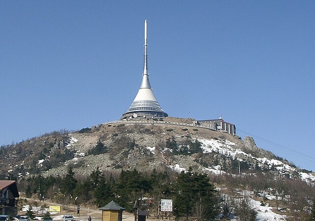
Čeština: Hora Ještěd
Deutsch: Der Jeschken nahe Reichenberg im Norden Tschechiens
English: Ještěd mountain, north of the Czech Republic |
||||||||
| Date | |||||||||
| Source | (transwikied from de:, original uploader de:Benutzer:Zaufatsch) | ||||||||
| Author | Bernd Gutte | ||||||||
| Permission (Reusing this file) |
|

| Camera location | | View this and other nearby images on: OpenStreetMap |
|---|
Awards
This image was selected as picture of the day on Wikimedia Commons for 19 September 2005. It was captioned as follows: Other languages:
Brezhoneg : Menez Ještěd er Republik Tchek. Un adkaser hag ul leti zo war al lein anezhañ. Cymraeg: Mynydd Ještěd yn y Weriniaeth Tsiec. Mae gwesty a thrawsyrrydd ar gopa'r mynydd. Español: Monte Ještěd en la República Checa. Hay una antena y un hotel en la cima. Français : Le mont Ještěd en République tchèque, un relais hertzien et un hôtel en occupent le sommet Latina: Bohemiae mons nomine Ještěd (Germanis Jeschken). Deversorium et instrumentum emissorium ad cacumen sunt. Nederlands: De berg Ještěd in Tsjechië met een transmitter en een hotel op de top. Norsk nynorsk: Fjellet Ještěd i Tsjekkia med radiomast og hotell på toppen. Português: Montanha de Ještěd na República Checa. No topo da montanha existe um transmissor e um hotel. ไทย: ยอดเขาเย็ชเทดในสาธารณรัฐเช็ก บนยอดเขามีสายอากาศส่งสัญญาณและโรงแรมตั้งอยู่ |
łahgo ádaalyaaígíí
Ńtʼę́ę́ʼígíí yíníʼį́įgo biniiyé, naʼalkid/yoołkáłígíí bikáaʼgi "click" ádíílííł
| naʼalkid/yoołkáłígíí | thumbnailígíí | naaniigo/náásee | Choyoołʼįįhí | haneʼ | |
|---|---|---|---|---|---|
| kʼadígíí | 08:31, 1 Biniʼantʼą́ą́tsoh 2011 | | 1,449 × 1,018 (1.19 TÁÁŁTSOHʼÍÍŁKÉ) | Lindi44 | one degree counterclockwise rotated |
| 09:47, 5 Tʼą́ą́chil 2005 |  | 1,467 × 1,044 (786 KIIŁTSOHʼÍÍŁKÉ) | Mormegil | Ještěd mountain, north of the Czech Republic *Source: photo taken on February 17, 2002 *Author: Bernd Gutte *License: GNU FDL (transwikied from de:, original uploader de:Benutzer:Zaufatsch) {{GFDL}} |
''Wikiibíídiiya'' bikáaʼgi choolʼį́/yitʼį́
(eʼelyaaígíí doo choolʼį́į da)
ałʼąą dineʼé bizaadjí
- ar.wikipedia.org bikáaʼgi
- arz.wikipedia.org bikáaʼgi
- ast.wikipedia.org bikáaʼgi
- azb.wikipedia.org bikáaʼgi
- be.wikipedia.org bikáaʼgi
- bg.wikipedia.org bikáaʼgi
- ca.wikipedia.org bikáaʼgi
- ceb.wikipedia.org bikáaʼgi
- ce.wikipedia.org bikáaʼgi
- cs.wikipedia.org bikáaʼgi
- de.wikipedia.org bikáaʼgi
- de.wikivoyage.org bikáaʼgi
- dsb.wikipedia.org bikáaʼgi
- en.wikipedia.org bikáaʼgi
- eo.wikipedia.org bikáaʼgi
- es.wikipedia.org bikáaʼgi
- fa.wikipedia.org bikáaʼgi
- fi.wikipedia.org bikáaʼgi
- fr.wikipedia.org bikáaʼgi
- hr.wikipedia.org bikáaʼgi
- hsb.wikipedia.org bikáaʼgi
- hu.wikipedia.org bikáaʼgi
View more global usage of this file.