
Eʼelyaaígíí:Mapa Myodes glareolus.png

Size of this preview: 800 × 407 pixels. Other resolutions: 320 × 163 pixels | 640 × 325 pixels | 1,024 × 521 pixels | 1,280 × 651 pixels | 2,753 × 1,400 pixels.
''full resolution''ígíí yishʼį́ nisin (2,753 × 1,400 pixels - 148 KIIŁTSOHʼÍÍŁKÉ, MIME type: image/png)
Summary
| Description |
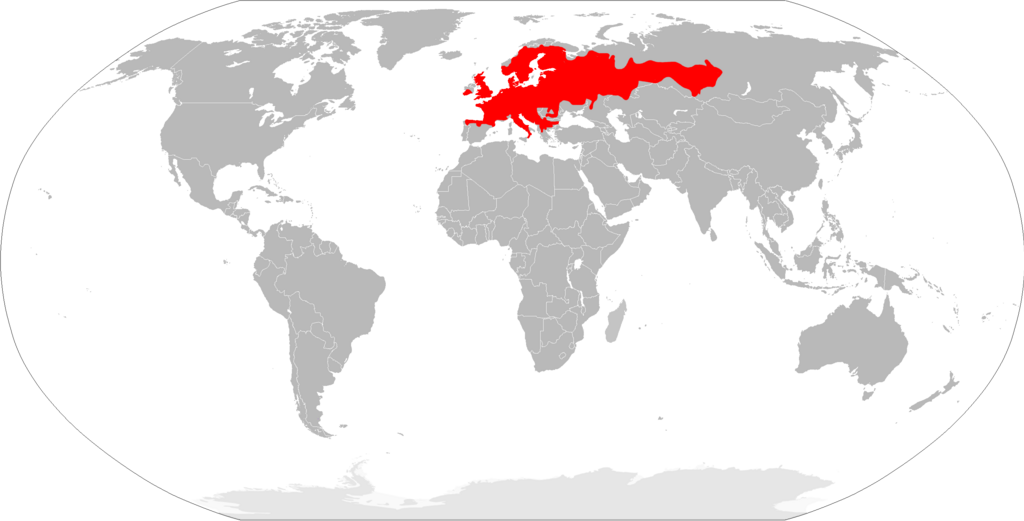
English: Range map of bank vole (Myodes glareolus).
Español: Mapa de distribución del topillo rojo (Myodes glareolus). |
| Date | |
| Source | Own work |
| Author | Osado |
Data source: IUCN
Licensing
| I, the copyright holder of this work, release this work into the public domain. This applies worldwide. In some countries this may not be legally possible; if so: I grant anyone the right to use this work for any purpose, without any conditions, unless such conditions are required by law. |
łahgo ádaalyaaígíí
Ńtʼę́ę́ʼígíí yíníʼį́įgo biniiyé, naʼalkid/yoołkáłígíí bikáaʼgi "click" ádíílííł
| naʼalkid/yoołkáłígíí | thumbnailígíí | naaniigo/náásee | Choyoołʼįįhí | haneʼ | |
|---|---|---|---|---|---|
| kʼadígíí | 22:07, 20 Wóózhchʼį́į́d 2018 | | 2,753 × 1,400 (148 KIIŁTSOHʼÍÍŁKÉ) | Maphobbyist | South Sudan border |
| 11:57, 17 Atsá Biyáázh 2010 |  | 2,753 × 1,400 (151 KIIŁTSOHʼÍÍŁKÉ) | Osado | {{Information |Description={{en|1=Range map of bank vole (''Myodes glareolus'').}} {{es|1=Mapa de distribución del topillo rojo (''Myodes glareolus'').}} |Source={{own}} |Author=Osado |Date=2010 |Permission= |other_versions= }} Data source |
''Wikiibíídiiya'' bikáaʼgi choolʼį́/yitʼį́
ałʼąą dineʼé bizaadjí
- an.wikipedia.org bikáaʼgi
- arz.wikipedia.org bikáaʼgi
- ast.wikipedia.org bikáaʼgi
- avk.wikipedia.org bikáaʼgi
- be-tarask.wikipedia.org bikáaʼgi
- bg.wikipedia.org bikáaʼgi
- ca.wikipedia.org bikáaʼgi
- ceb.wikipedia.org bikáaʼgi
- cs.wikipedia.org bikáaʼgi
- cy.wikipedia.org bikáaʼgi
- de.wikipedia.org bikáaʼgi
- en.wikipedia.org bikáaʼgi
- es.wikipedia.org bikáaʼgi
- et.wikipedia.org bikáaʼgi
- eu.wikipedia.org bikáaʼgi
- fi.wikipedia.org bikáaʼgi
- fr.wikipedia.org bikáaʼgi
- Liste des mammifères en France métropolitaine
- Liste des mammifères en Belgique
- Liste des mammifères en Espagne
- Liste des mammifères en Suisse
- Liste des mammifères au Luxembourg
- Liste des mammifères en Italie
- Liste des mammifères en Allemagne
- Liste des mammifères au Royaume-Uni
- Liste des mammifères aux Pays-Bas européens
- Liste des mammifères en Roumanie
- Liste des mammifères en Norvège
- Liste des mammifères en Grèce
- Liste des mammifères en Autriche
- Liste des mammifères en Pologne
- Liste des mammifères en Andorre
- Liste des mammifères au Danemark
- Liste des mammifères en Irlande
- Liste des mammifères en Suède
- Liste des mammifères en Tchéquie
- Liste des mammifères en Finlande
- Liste des mammifères en Croatie
- Liste des mammifères en Hongrie
- Liste des mammifères en Ukraine
- Liste des mammifères à Saint-Marin
- Liste des mammifères au Liechtenstein
- Liste des mammifères en Serbie
View more global usage of this file.