Eʼelyaaígíí:American Three-toed Woodpecker Picoides dorsalis distribution map 2.png

Page contents not supported in other languages.
"Wikiibíídiiya" bitsʼą́ą́dę́ę́ʼ

''full resolution''ígíí yishʼį́ nisin(756 × 800 pixels - 129 KIIŁTSOHʼÍÍŁKÉ, MIME type: image/png)


Díí kweʼé eʼelyaaígíí éí Wikimedia Commons bitsʼą́ą́dę́ę́ʼ.
(Díí naaltsoos bikáaʼgi saad shijaaʼígíí éí yaa halneʼígíí (Wikimedia Commonsdi) bitsʼą́ą́dóó)


Summary

Description
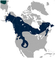
English: Geographical distribution of the American Three-toed Woodpecker Picoides dorsalis (navy). A small portion of the Eurasian Three-toed Woodpecker Picoides tridactylus range is visible in the upper left corner (deep cyan). Includes state and province borders.

Note: IUCN does not recognize Picoides dorsalis as separate species.

The map was created using the Generic Mapping Tools, GMT, version 5.1.2.
Date
Source

Own work using: the IUCN Red List spatial data to draw the borders of the Picoides dorsalis and Picoides tridactylus range:
http://maps.iucnredlist.org/map.html?id=22727137
Credit for the spatial data:
BirdLife International and NatureServe (2014) Bird Species Distribution Maps of the World. 2014. Picoides tridactylus. In: IUCN 2014. The IUCN Red List of Threatened Species. Version 2014.3. http://www.iucnredlist.org. Downloaded on 26 May 2015.
Species account:
http://www.iucnredlist.org/details/22727137/0
BirdLife International 2014. Picoides tridactylus. The IUCN Red List of Threatened Species. Version 2014.3. <www.iucnredlist.org>. Downloaded on 26 May 2015.

 
This map was created with GMT.
Author Darekk2 using the IUCN Red List spatial data
Other versions Without Picoides tridactylus:
American Three-toed Woodpecker Picoides dorsalis distribution map.png

Licensing

Attribution: The author of the work and the IUCN Red List spatial data.
You must provide the appropriate credit for the IUCN Red List spatial data:
BirdLife International and NatureServe (2014) Bird Species Distribution Maps of the World. 2014. Picoides tridactylus. In: IUCN 2014. The IUCN Red List of Threatened Species. Version 2014.3. http://www.iucnredlist.org. Downloaded on 26 May 2015.

w:en:Creative Commons
attribution share alike
This file is licensed under the Creative Commons Attribution-Share Alike 4.0 International license.
Attribution: The author of the work
and the IUCN Red List spatial data
You are free:
  • to share – to copy, distribute and transmit the work
  • to remix – to adapt the work
Under the following conditions:
  • attribution – You must give appropriate credit, provide a link to the license, and indicate if changes were made. You may do so in any reasonable manner, but not in any way that suggests the licensor endorses you or your use.
  • share alike – If you remix, transform, or build upon the material, you must distribute your contributions under the same or compatible license as the original.

Captions

Add a one-line explanation of what this file represents

Items portrayed in this file

depicts English

copyrighted English

inception English

26 Tʼą́ą́tsoh 2015

media type English

image/png

checksum English

368cc7891e05ada5c94d07abb36f60eec1d9ed79

determination method English: SHA-1 English

data size English

132,062 byte

height English

800 pixel

width English

756 pixel

łahgo ádaalyaaígíí

( Anáʼálwoʼ:Íʼneelʼąąhígíí)


Ńtʼę́ę́ʼígíí yíníʼį́įgo biniiyé, naʼalkid/yoołkáłígíí bikáaʼgi "click" ádíílííł

naʼalkid/yoołkáłígííthumbnailígíínaaniigo/nááseeChoyoołʼįįhíhaneʼ
kʼadígíí02:29, 27 Tʼą́ą́tsoh 2015thumbnailígíí (02:29, 27 Tʼą́ą́tsoh 2015)756 × 800 (129 KIIŁTSOHʼÍÍŁKÉ)Darekk2thinner borders of states
18:48, 26 Tʼą́ą́tsoh 2015thumbnailígíí (18:48, 26 Tʼą́ą́tsoh 2015)757 × 800 (133 KIIŁTSOHʼÍÍŁKÉ)Darekk2thicker borders of states
18:21, 26 Tʼą́ą́tsoh 2015thumbnailígíí (18:21, 26 Tʼą́ą́tsoh 2015)756 × 800 (125 KIIŁTSOHʼÍÍŁKÉ)Darekk2User created page with UploadWizard

ałʼąą dineʼé bizaadjí