
Eʼelyaaígíí:CalGoldRushMap.jpg

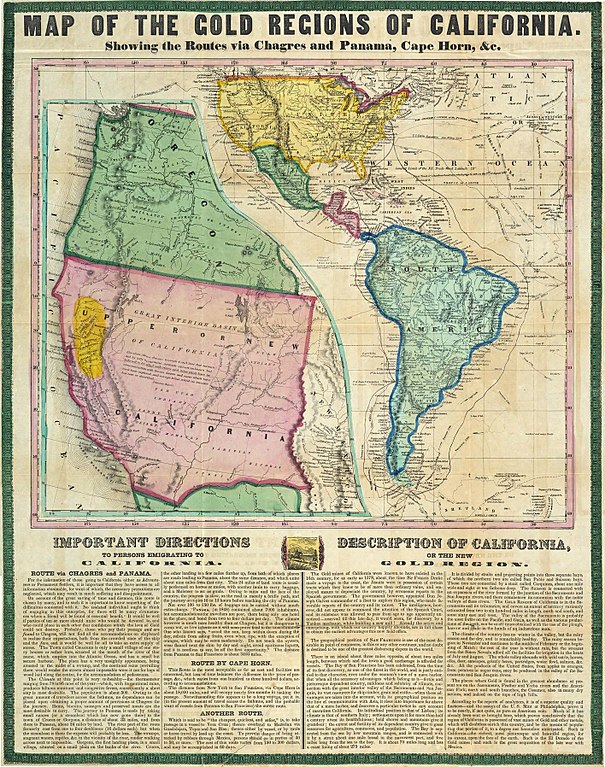
''full resolution''ígíí yishʼį́ nisin (1,416 × 1,796 pixels - 1.18 TÁÁŁTSOHʼÍÍŁKÉ, MIME type: image/jpeg)
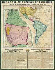
| Description | Map of the Gold Regions of California, Showing the Routes via | ||||
| Date | |||||
| Source | David Rumsey Map Collection | ||||
| Author | Ensigns & Thayer | ||||
| Permission (Reusing this file) |
|
||||
Original Source -
Map of the Gold Regions of California, Showing Routes Historic Maps of the California Gold Rush
łahgo ádaalyaaígíí
Ńtʼę́ę́ʼígíí yíníʼį́įgo biniiyé, naʼalkid/yoołkáłígíí bikáaʼgi "click" ádíílííł
| naʼalkid/yoołkáłígíí | thumbnailígíí | naaniigo/náásee | Choyoołʼįįhí | haneʼ | |
|---|---|---|---|---|---|
| kʼadígíí | 12:44, 22 Biniʼantʼą́ą́tsoh 2011 | | 1,416 × 1,796 (1.18 TÁÁŁTSOHʼÍÍŁKÉ) | Soerfm | Higher resolution |
| 00:11, 7 Yaʼiishjááshchilí 2007 |  | 618 × 768 (111 KIIŁTSOHʼÍÍŁKÉ) | Akarrer~commonswiki | {{Information |Description=Map of the Gold Regions of California, Showing the Routes via |Source=David Rumsey Map Collection |Date=1849 |Author=Ensigns & Thayer |Permission={{cc-by-sa-2.0}} |other_versions= }} |
''Wikiibíídiiya'' bikáaʼgi choolʼį́/yitʼį́
ałʼąą dineʼé bizaadjí
- da.wikipedia.org bikáaʼgi
- en.wikipedia.org bikáaʼgi
- fr.wikipedia.org bikáaʼgi
- ga.wikipedia.org bikáaʼgi
- he.wikipedia.org bikáaʼgi
- hu.wikipedia.org bikáaʼgi
- ja.wikipedia.org bikáaʼgi
- pl.wikipedia.org bikáaʼgi
- sv.wikipedia.org bikáaʼgi
- vi.wikipedia.org bikáaʼgi