
Eʼelyaaígíí:Africa land cover location mamba map with borders.jpg

Size of this preview: 635 × 600 pixels. Other resolutions: 254 × 240 pixels | 508 × 480 pixels | 813 × 768 pixels | 1,084 × 1,024 pixels | 1,525 × 1,440 pixels.
''full resolution''ígíí yishʼį́ nisin (1,525 × 1,440 pixels - 928 KIIŁTSOHʼÍÍŁKÉ, MIME type: image/jpeg)
Summary
| Description |
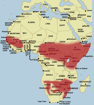
English: Map of geographical range of the black mamba in Africa. Source of information displayed is this or more specifically this linked file. |
||
| Date | March 12, 2019 based on earlier version published 28 Níłchʼitsʼósí 2013, 05:10:11 (upload date); the source data displays a file modified date of March 22, 2013 | ||
| Source | File:Africa location map black mamba distribution.svg overlaid on File:Africa location map.svg | ||
| Author | Samsara using work by Sameboat and Sting | ||
| Permission (Reusing this file) |
This file is licensed under the Creative Commons Attribution-Share Alike 3.0 Unported license.
You may select the license of your choice. |

łahgo ádaalyaaígíí
Ńtʼę́ę́ʼígíí yíníʼį́įgo biniiyé, naʼalkid/yoołkáłígíí bikáaʼgi "click" ádíílííł
| naʼalkid/yoołkáłígíí | thumbnailígíí | naaniigo/náásee | Choyoołʼįįhí | haneʼ | |
|---|---|---|---|---|---|
| kʼadígíí | 21:01, 12 Wóózhchʼį́į́d 2019 | | 1,525 × 1,440 (928 KIIŁTSOHʼÍÍŁKÉ) | Samsara | {{Information |description ={{en|1=Map of geographical range of the black mamba in Africa. Source of information displayed is [http://www.toxinology.com/fusebox.cfm?fuseaction=main.snakes.display&id=SN0170 this] or more specifically [http://www.toxinology.com/images/snakes/SNMS0170.gif this linked file].}} |date =March 12, 2019 based on earlier version published {{Upload date|2013-11-28 05:10:11}}; the source data displays a file modified date of March 22, 2013 |source =[[:F... |
''Wikiibíídiiya'' bikáaʼgi choolʼį́/yitʼį́
ałʼąą dineʼé bizaadjí
- ar.wikipedia.org bikáaʼgi
- arz.wikipedia.org bikáaʼgi
- bg.wikipedia.org bikáaʼgi
- bn.wikipedia.org bikáaʼgi
- ca.wikipedia.org bikáaʼgi
- ceb.wikipedia.org bikáaʼgi
- cs.wikipedia.org bikáaʼgi
- dty.wikipedia.org bikáaʼgi
- en.wikipedia.org bikáaʼgi
- es.wikipedia.org bikáaʼgi
- eu.wikipedia.org bikáaʼgi
- he.wikipedia.org bikáaʼgi
- hi.wikipedia.org bikáaʼgi
- hu.wikipedia.org bikáaʼgi
- id.wikipedia.org bikáaʼgi
- it.wikipedia.org bikáaʼgi
- kw.wikipedia.org bikáaʼgi
- ml.wikipedia.org bikáaʼgi
- ne.wikipedia.org bikáaʼgi
- pt.wikipedia.org bikáaʼgi
- sk.wikipedia.org bikáaʼgi
- sv.wikipedia.org bikáaʼgi
- tr.wikipedia.org bikáaʼgi
- uz.wikipedia.org bikáaʼgi
- www.wikidata.org bikáaʼgi
- zh.wikipedia.org bikáaʼgi