
Eʼelyaaígíí:Mapa Ammotragus lervia.png

Size of this preview: 800 × 351 pixels. Other resolutions: 320 × 140 pixels | 640 × 281 pixels | 1,425 × 625 pixels.
''full resolution''ígíí yishʼį́ nisin (1,425 × 625 pixels - 47 KIIŁTSOHʼÍÍŁKÉ, MIME type: image/png)
Summary
| Description |
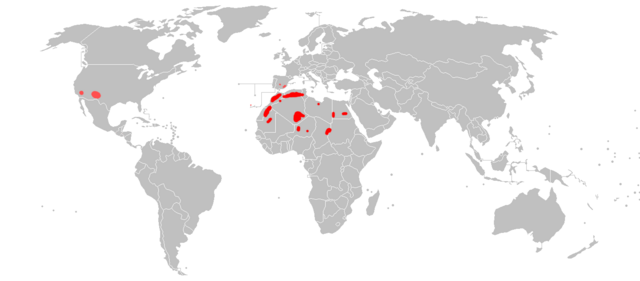
English: Distribution map of Ammotragus lervia. Original zone (red) and zone where it has been introduded (pink).
Español: Mapa de distribución del arruì (Ammotragus lervia). Área original (en rojo) y área donde ha sido introducido (en rosa). |
| Date | |
| Source | Own work |
| Author | Osado |
Data source: Enciclopedia virtual de los vertebrados españoles (in Spanish)
Licensing
| I, the copyright holder of this work, release this work into the public domain. This applies worldwide. In some countries this may not be legally possible; if so: I grant anyone the right to use this work for any purpose, without any conditions, unless such conditions are required by law. |
łahgo ádaalyaaígíí
Ńtʼę́ę́ʼígíí yíníʼį́įgo biniiyé, naʼalkid/yoołkáłígíí bikáaʼgi "click" ádíílííł
| naʼalkid/yoołkáłígíí | thumbnailígíí | naaniigo/náásee | Choyoołʼįįhí | haneʼ | |
|---|---|---|---|---|---|
| kʼadígíí | 18:33, 21 Wóózhchʼį́į́d 2018 | | 1,425 × 625 (47 KIIŁTSOHʼÍÍŁKÉ) | Maphobbyist | South Sudan border |
| 12:06, 4 Atsá Biyáázh 2010 |  | 1,425 × 625 (46 KIIŁTSOHʼÍÍŁKÉ) | Osado | {{Information |Description={{en|1=Distribution map of ''Ammotragus lervia''. Original zone (red) and zone where it has been introduded (pink).}} {{es|1=Mapa de distribución del coipú (''Ammotragus lervia''). Área original (en rojo) y área donde ha sid |
''Wikiibíídiiya'' bikáaʼgi choolʼį́/yitʼį́
ałʼąą dineʼé bizaadjí
- an.wikipedia.org bikáaʼgi
- ar.wikipedia.org bikáaʼgi
- arz.wikipedia.org bikáaʼgi
- avk.wikipedia.org bikáaʼgi
- bg.wikipedia.org bikáaʼgi
- ca.wikipedia.org bikáaʼgi
- cs.wikipedia.org bikáaʼgi
- el.wikipedia.org bikáaʼgi
- es.wikipedia.org bikáaʼgi
- eu.wikipedia.org bikáaʼgi
- fr.wikipedia.org bikáaʼgi
- ga.wikipedia.org bikáaʼgi
- gl.wikipedia.org bikáaʼgi
- he.wikipedia.org bikáaʼgi
- hr.wikipedia.org bikáaʼgi
- hu.wikipedia.org bikáaʼgi
- it.wikipedia.org bikáaʼgi
- ja.wikipedia.org bikáaʼgi
- kab.wikipedia.org bikáaʼgi
- ko.wikipedia.org bikáaʼgi
- pt.wikipedia.org bikáaʼgi
- sk.wikipedia.org bikáaʼgi
- sq.wikipedia.org bikáaʼgi
- www.wikidata.org bikáaʼgi
- zh.wikipedia.org bikáaʼgi