
Eʼelyaaígíí:Argentina orthographic.svg

Size of this PNG preview of this SVG file: 550 × 550 pixels. Other resolutions: 240 × 240 pixels | 480 × 480 pixels | 768 × 768 pixels | 1,024 × 1,024 pixels | 2,048 × 2,048 pixels.
''full resolution''ígíí yishʼį́ nisin (SVG / 550 × 550 / 691 KIIŁTSOHʼÍÍŁKÉ áníłtso)
Summary
| Description |
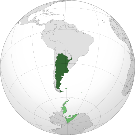
English: Orthographic map of Argentina centered on Buenos Aires
Official territory.
Claimed territories. Español: Mapa ortográfico de la Argentina centrado en Buenos Aires
Territorio oficial.
Territorios en disputa. |
| Date | |
| Source | Own work with Natural Earth Data |
| Author | Addicted04 |
| SVG genesis |
El único territorio que reclama son las malvinas, son los puntos verdes chiquitos, la antártida o el triangulo de abajo es argentino.
.svg)
.svg)
.svg)
.svg)
.svg)
.svg)
.svg)
.svg)
.svg)
.svg)
.svg)
.svg)
.svg)
.svg)
.svg)
.svg)
.svg)
.svg)
.svg)
.svg)
.svg)
.svg)
.svg)
.svg)
.svg)
.svg)
.svg)
.svg)
.svg)
.svg)
.svg)
.svg)
.svg)
.svg)
.svg)
.svg)
.svg)
.svg)
.svg)
.svg)
.svg)
.svg)
.svg)
.svg)
.svg)
.svg)
.svg)
.svg)
.svg)
.svg)
.svg)
.svg)
.svg)
.svg)
.svg)
.svg)
.svg)
.svg)
.svg)
.svg)
.svg)
.svg)
.svg)
.svg)
.svg)
.svg)
.svg)
.svg)
.svg)
.svg)
.svg)
.svg)
.svg)
.svg)

.svg)

.svg)

.svg)
.svg)
.svg)
.svg)
.svg)
.svg)
.svg)


.svg)
.svg)
.svg)
.svg)
.svg)
.svg)
.svg)

.svg)
.svg)
.svg)
.svg)
.svg)
.svg)
.svg)
.svg)
.svg)

.svg)
.svg)
.svg)
.svg)
.svg)
.svg)
.svg)
_without_national_boundaries.svg)
.svg)
.svg)
.svg)
.svg)
.svg)
.svg)

.svg)
.svg)
.png)
.svg)
.svg)
.svg)
.svg)

.svg)
.svg)
.svg)
.svg)
.svg)
.svg)
.svg)
.svg)
.svg)
.svg)
.svg)

.svg)
.svg)
.svg)
.svg)
.svg)
.svg)
.svg)
.svg)
.svg)

.svg)
.svg)

.svg)
.svg)
.svg)
.svg)
.svg)
.svg)
.svg)
.svg)
.svg)
.svg)
.svg)
.svg)
.svg)
.svg)
.svg)
.svg)
.svg)
.svg)
.svg)
.svg)
.svg)
.svg)
.svg)
.svg)
.svg)
.svg)
.svg)
_-_Crimea_disputed.svg)
.svg)
.svg)
.svg)
.svg)
.svg)
.svg)
.svg)
.svg)
.svg)
.svg)
.svg)
_political.svg)
.svg)
.svg)
.svg)
.svg)
_-_Crimea_disputed_-_no_borders.svg)
.svg)
.svg)
.svg)
.svg)
.svg)
.svg)
.svg)
.svg)
.svg)
.svg)
.svg)

.svg)
.svg)
.svg)

.png)
.svg)
.svg)
.svg)
.svg)
.svg)
.svg)
.svg)
.svg)
.svg)
.svg)
.svg)
.svg)
.svg)
.svg)
.svg)
.svg)
.svg)
.svg)
.svg)
.svg)
.svg)
.svg)
.svg)
.svg)
.svg)
.svg)
.svg)
.svg)
.svg)
.svg)
.svg)
.svg)
.svg)
.svg)
.png)
.svg)
.svg)
.svg)
_(orthographic_projection).png)
| Orthographic projections maps created by Ssolbergj |
|---|
| Orthographic projections maps created by Ssolbergj: |
.svg)
.svg)
Licensing
I, the copyright holder of this work, hereby publish it under the following license:
This file is licensed under the Creative Commons Attribution 3.0 Unported license.
- You are free:
- to share – to copy, distribute and transmit the work
- to remix – to adapt the work
- Under the following conditions:
- attribution – You must give appropriate credit, provide a link to the license, and indicate if changes were made. You may do so in any reasonable manner, but not in any way that suggests the licensor endorses you or your use.
łahgo ádaalyaaígíí
Ńtʼę́ę́ʼígíí yíníʼį́įgo biniiyé, naʼalkid/yoołkáłígíí bikáaʼgi "click" ádíílííł
| naʼalkid/yoołkáłígíí | thumbnailígíí | naaniigo/náásee | Choyoołʼįįhí | haneʼ | |
|---|---|---|---|---|---|
| kʼadígíí | 16:48, 18 Yaʼiishjáástsoh 2013 | | 550 × 550 (691 KIIŁTSOHʼÍÍŁKÉ) | Montgomery | Reverted to version as of 22:50, 22 October 2011; COM:GL/M standars |
| 16:08, 18 Yaʼiishjáástsoh 2013 |  | 550 × 550 (697 KIIŁTSOHʼÍÍŁKÉ) | Cesardavidd | Reverted to version as of 20:32, 22 June 2011 | |
| 22:50, 22 Ghąąjįʼ 2011 |  | 550 × 550 (691 KIIŁTSOHʼÍÍŁKÉ) | Addicted04 | claimed color | |
| 22:39, 22 Ghąąjįʼ 2011 |  | 550 × 550 (690 KIIŁTSOHʼÍÍŁKÉ) | Addicted04 | claimed color | |
| 20:32, 22 Yaʼiishjááshchilí 2011 |  | 550 × 550 (697 KIIŁTSOHʼÍÍŁKÉ) | Addicted04 | latitude line | |
| 21:08, 21 Yaʼiishjááshchilí 2011 |  | 550 × 550 (692 KIIŁTSOHʼÍÍŁKÉ) | Addicted04 |
''Wikiibíídiiya'' bikáaʼgi choolʼį́/yitʼį́
(eʼelyaaígíí doo choolʼį́į da)
ałʼąą dineʼé bizaadjí
- an.wikipedia.org bikáaʼgi
- ar.wikipedia.org bikáaʼgi
- as.wikipedia.org bikáaʼgi
- av.wikipedia.org bikáaʼgi
- awa.wikipedia.org bikáaʼgi
- ay.wikipedia.org bikáaʼgi
- azb.wikipedia.org bikáaʼgi
- bh.wikipedia.org bikáaʼgi
- bm.wikipedia.org bikáaʼgi
- bn.wikipedia.org bikáaʼgi
- bo.wikipedia.org bikáaʼgi
- bpy.wikipedia.org bikáaʼgi
- br.wikipedia.org bikáaʼgi
- bxr.wikipedia.org bikáaʼgi
- ca.wikipedia.org bikáaʼgi
- cbk-zam.wikipedia.org bikáaʼgi
- cdo.wikipedia.org bikáaʼgi
- ceb.wikipedia.org bikáaʼgi
- chr.wikipedia.org bikáaʼgi
- ch.wikipedia.org bikáaʼgi
- co.wikipedia.org bikáaʼgi
- crh.wikipedia.org bikáaʼgi
- cv.wikipedia.org bikáaʼgi
- de.wiktionary.org bikáaʼgi
- dsb.wikipedia.org bikáaʼgi
- dty.wikipedia.org bikáaʼgi
- ee.wikipedia.org bikáaʼgi
- en.wikipedia.org bikáaʼgi
- es.wikipedia.org bikáaʼgi
- Categoría:Provincia de Buenos Aires
- Categoría:Provincia de Catamarca
- Categoría:Provincia de Chaco
- Categoría:Provincia de Córdoba (Argentina)
- Categoría:Provincia de Corrientes
- Categoría:Provincia de Entre Ríos
- Categoría:Provincia de Formosa
- Categoría:Provincia de Jujuy
- Categoría:Provincia de La Pampa
- Categoría:Provincia de La Rioja (Argentina)
- Categoría:Provincia de Mendoza
- Categoría:Provincia de Río Negro
- Categoría:Provincia de Salta
View more global usage of this file.